
Stepping out of an international terminal into a bustling rail hub without an active eSIM or cellular signal can trigger immediate dread. I learned early on that relying on costly roaming packages or spotty public Wi-Fi is an unnecessary gamble. Learning how to navigate public transit in foreign countries without data comes down to using your smartphone’s built-in sensors properly and deciphering physical station clues that most travelers ignore.
Your phone’s internal receiver connects directly to orbiting satellites without requiring a cellular network or active data stream, as confirmed by GPS.gov. With the right setup on hotel Wi-Fi before heading out, riding unfamiliar subway, tram, and commuter rail systems becomes entirely frictionless.
Offline Transit Apps That Function Without Cellular Service
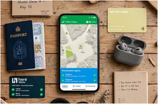
Most standard map apps assume continuous data access. Finding the right tools means selecting options that maintain their database locally on your storage drive.
Why Offline Google Maps Falls Short for Subways
I keep a downloaded regional map on Google Maps everywhere I travel. However, the official Google Maps Support documentation highlights a critical limitation: downloaded maps only calculate driving routes.
Offline Google Maps will show your real-time blue location pin moving down a street. It will not calculate complex transfers, bus schedules, or platform numbers without an active connection. Using it as your sole public transit planner leaves you stranded once you head underground.
Dedicated Offline Journey Planners: Organic Maps and HERE WeGo
For true offline routing, I switch between two dedicated alternatives:
- Organic Maps: Powered by crowdsourced data from the OpenStreetMap Foundation, this lightweight utility stores full city infrastructure on your device. Once you download your destination region over Wi-Fi, it plots pedestrian transfers and basic transit pathways completely unplugged.
- HERE WeGo: This app allows entire country map packs to be saved for offline use. It retains robust city transit architectures offline, making it indispensable when I need to plan a 3 week cross country train trip spanning multiple regional operators.
The Wi-Fi Route Caching Method for Live Subway Navigation

When I visit dense metro areas like London, Paris, or Tokyo, I lean on specialized transit tools such as Citymapper or Moovit. You can force these dynamic apps to run offline using a simple pre-departure sequence.
- Connect to your accommodation’s Wi-Fi network before stepping outside.
- Plug in your destination and pull up the full, expanded itinerary.
- Expand every transfer leg so the app calls down station names, platform numbers, and exit designations.
- Keep the application open in your background apps tray without swiping it closed.
Mobile operating systems hold this routing data in active memory cache. While your turn-by-turn ETA will freeze, the station sequences and interchange instructions remain intact.
Always snap sequential screenshots of the route steps as an immediate visual backup in case your phone restarts. Keeping a portable battery pack on hand is another non-negotiable step highlighted in my essential packing checklist for long term slow travel.
Reading Station Infrastructure Like a Local
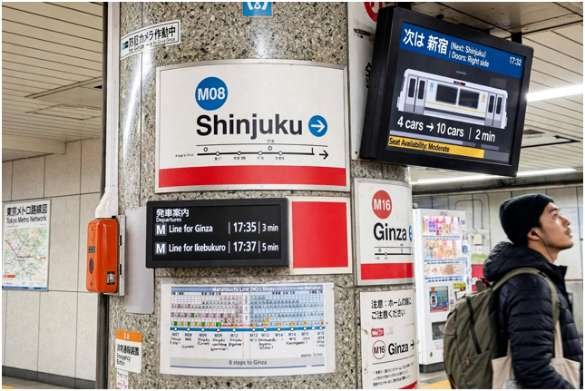
Physical station wayfinding is engineered to guide commuters who do not speak the local dialect or carry a functional smartphone.
Decode Alphanumeric Platform Codes
Reading non-Latin scripts under pressure causes costly navigational delays. Advanced transit authorities bypass language barriers using standardized alphanumeric labeling.
During my first month navigating the Tokyo Metro, reading kanji station boards proved exhausting. I quickly switched to tracking station codes: Line Letter plus Station Number.
To travel from Shinjuku (M08) to Ginza (M16) on the Marunouchi Line, count forward eight stops. Watch the digital car monitors or platform pillar signs count up sequentially, ignoring the language barrier entirely.
Identify the Terminus Station Before Boarding
Platform signs across Europe and East Asia rarely state “Eastbound” or “Uptown.” Instead, platform signboards display the name of the line’s final stop (the terminus).
Before passing the turnstiles, scan the overall line diagram to find the end station in your travel direction. If you need to travel three stops toward the city center, board the platform marked with that distant terminal city. Boarding without checking the terminus is the fastest way to hop onto an express train speeding in the opposite direction.
Emergency Offline Backups When Your Digital Map Fails
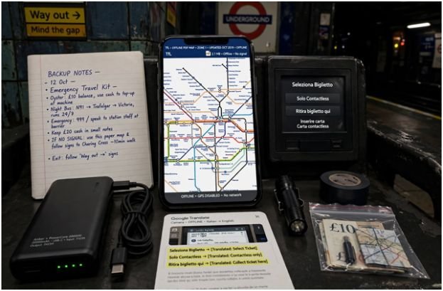
When digital tools crash or battery levels deplete, analog fallbacks keep you moving forward.
- Native Transit Agency PDF Maps: Official operators such as Transport for London (TfL) supply vector-based PDF system maps. Download these files directly to your mobile browser or document reader. Unlike raster images, PDF vectors let you zoom into complex station hubs without pixel blur.
- Offline Translation Engines: Install your destination language within Google Translate for offline access. The camera translation feature works locally on physical signs, ticket dispensing kiosks, and detour alerts without cellular data.
- Anchor Hub Wi-Fi: When a transit line undergoes sudden maintenance, locate the closest central rail concourse, library, or international chain cafe. These spots offer open public Wi-Fi networks where you can recalibrate and cache a new transit path.
Unplugged and On Track: Your Commute Beyond Cellular Range
Navigating foreign transit systems without a cellular signal isn’t a limitation; it forces you to become a more observant traveler. Download your regional map data ahead of time, lock in your route stops on morning Wi-Fi, and let physical transit signage guide your steps.
Before you step onto the platform tomorrow, pick one subway line, verify its final terminus station, and make your connection completely offline.
Frequently Asked Questions
1. Does phone GPS work overseas without cellular data or roaming?
Yes, smartphone GPS chips communicate directly with orbital satellites and pinpoint your physical coordinates anywhere on earth with zero cellular reception.
2. Can I get live transit transfer directions on offline Google Maps?
No, Google Maps restricts offline usage to driving directions and saved map viewing, requiring data for public transit routing.
3. What is the best free app for offline international subway maps?
Organic Maps and HERE WeGo deliver dependable, full offline navigation with local transit layers sourced from open mapping databases.
4. How do I identify the correct subway platform without reading the language?
Check the physical route map to identify the last station on the line in your direction of travel, then locate the platform sign displaying that terminus name.