
Tour buses miss the pulse of historic Europe. You discover centuries of culture in the narrow alleys, forgotten courtyards, and worn stone steps where coaches cannot fit. I have spent years field-testing self guided walking itineraries in historic European cities, learning firsthand how to navigate ancient urban footprints on my own schedule.
Solo foot travel gives you the freedom to linger at an open sculpture courtyard or duck into a basement espresso bar. With sensible preparation and offline navigation, you can experience the world’s most historic streetscapes without paying for rigid group excursions.
How I Map Walkable Old Towns Without Guided Tours
The biggest mistake travelers make is wandering without a spatial plan. Medieval and Renaissance street layouts were built for defense or trade, not modern GPS satellites. Tall stone palazzi routinely bounce mobile signals, leaving you stranded in dead zones.
Before I head out, I always cache vector offline maps on my phone. I also pack light enough so I can seamlessly travel internationally without checking luggage, keeping my hands free and mobility high from the moment I leave the train station.
1. The Florence Renaissance Loop (Tuscany, Italy)
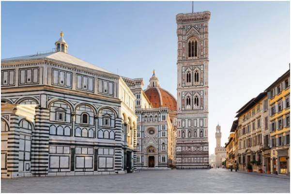
Florence is an open-air museum concentrated into an astonishingly walkable river basin. The entire core is recognized by the UNESCO World Heritage Centre for its concentration of 15th-century masterworks.
Piazza del Duomo ──> Via dei Calzaiuoli ──> Piazza della Signoria ──> Uffizi Corridor ──> Ponte Vecchio
Key Waypoints and Street-Level Navigation
Start early at 7:30 AM at the Piazza del Duomo. Viewing Brunelleschi’s terracotta dome in early morning light without mid-morning crowds is unbeatable.
Head south along Via dei Calzaiuoli, a flat, paved pedestrian street. You will spill into Piazza della Signoria, where cell signals often drop near the heavy stone walls of the Palazzo Vecchio. Admire the outdoor sculptures, pass the shaded loggia of the Uffizi Gallery, and finish over the medieval stone arches of the Ponte Vecchio.
| Route Metrics | Value | Practical Note |
| Total Distance | 2.0 km (1.2 miles) | Flat stone flags; slick when damp |
| Recommended Time | 2 to 3 hours | Add 45 minutes for a sit-down espresso |
| Best Start Window | 7:30 AM – 8:30 AM | Avoids tour groups clustering at Ponte Vecchio |
2. The Tallinn Medieval Fortress Trail (Estonia)
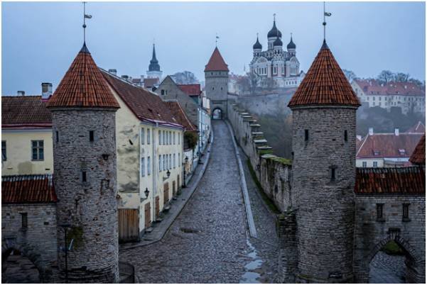
Tallinn features Northern Europe’s most intact 14th-century Gothic defensive core. The official Visit Tallinn Portal documents over two kilometers of original fortress walls and defensive towers guarding the modern city.
Viru Gate ──> Town Hall Square (Raekoja plats) ──> Lühike jalg (Short Leg) ──> Toompea Hill ──> Patkuli Platform
Upper Town Incline and Cobblestone Realities
Enter via the twin stone towers of Viru Gate. Walk west into Town Hall Square (Raekoja plats), surrounded by Gothic merchant homes.
From the square, locate Lühike jalg (Short Leg), a steep, stepped alleyway leading up to Toompea Hill. This upper fortress district houses the Russian Revival onion domes of the Alexander Nevsky Cathedral. Wrap up your walk at the Patkuli Viewing Platform, which delivers uninterrupted vistas across red-tiled roofs and the Baltic Sea.
| Route Metrics | Value | Practical Note |
| Total Distance | 2.5 km (1.5 miles) | Significant incline; uneven cobblestones |
| Recommended Time | 3 hours | Pace your climb up Toompea Hill |
| Footwear Requirement | Rigid lug-soled shoes | Smooth street sneakers will slip on round cobbles |
3. The Amsterdam Golden Age Canal Ring (Netherlands)
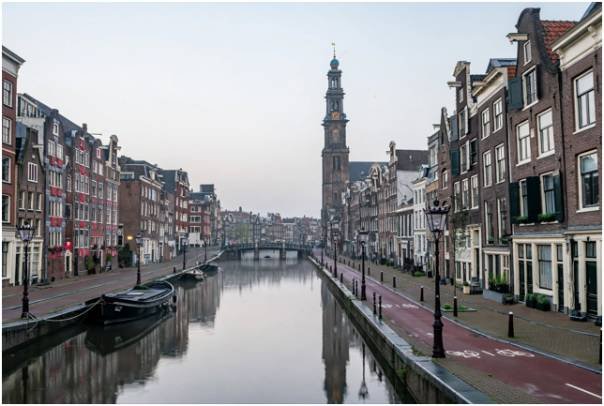
Amsterdam offers an entirely flat walk along 17th-century waterways and gabled facades. The canal grid is easy to follow, as detailed by the City of Amsterdam Official Tourism department.
Dam Square ──> Royal Palace ──> Jordaan Quarter ──> Prinsengracht ──> Westerkerk ──> Rembrandtplein
Avoiding Two-Wheeled Crossfire in the Jordaan
Begin at Dam Square, facing the Royal Palace. Walk west directly into the tranquil Jordaan Neighborhood.
Follow the Prinsengracht Canal south, keeping the water on your left. You will pass the historic Anne Frank House and the soaring spire of the Westerkerk. Conclude your loop by swinging eastward toward the lively cafes of Rembrandtplein.
The greatest hazard here is not traffic, but silent, fast-moving commuter bicycles. Always look behind you before stepping sideways to snap a canal photo.
| Route Metrics | Value | Practical Note |
| Total Distance | 4.0 km (2.5 miles) | Perfectly flat, brick-and-asphalt surfaces |
| Recommended Time | 3.5 to 4 hours | Account for footbridge navigation delays |
| Hazard Watch | Red asphalt bike tracks | Cyclists have legal right-of-way over walkers |
Route Comparison: Distances, Terrain, and Essential Tools
Planning your daily energy expenditure prevents mid-trip burnout. The table below outlines how these three historic walks match up in operational demands:
| City & Route | Walking Distance | Elevation Profile | Primary Street Surface | Recommended Digital Tool |
| Florence Loop | 2.0 km / 1.2 mi | Negligible (Flat) | Smooth stone flags | Rick Steves Audio Europe |
| Tallinn Fortress | 2.5 km / 1.5 mi | Steep incline (~50m gain) | 14th-century rough cobbles | Questo App (Offline Mode) |
| Amsterdam Ring | 4.0 km / 2.5 mi | Flat (bridges only) | Brick pavers and pavement | GPSmyCity Walking Maps |
Lace Up or Stay Home: My Final Route Takeaway
Historic European old towns reveal their best stories when you ditch the tour bus megaphone and explore on your own two feet.
Pick your route, download offline maps before leaving your room, and pack shoes with serious arch support. Start walking at first light, and you will have these legendary ancient streets entirely to yourself.
If you need to link different neighborhoods, take a quick minute to master how you navigate public transit in foreign countries so you can return to your base when your legs give out.
Frequently Asked Questions
1. Which European city has the most walkable historic center?
Florence offers the most accessible route due to its flat, concentrated pedestrian zone.
2. Are cobblestone streets difficult to walk on for long itineraries?
Yes, uneven cobbles cause foot fatigue quickly, requiring stiff soles with adequate arch support.
3. Do I need internet data for self guided city walks in Europe?
No, downloading offline maps over hotel Wi-Fi beforehand provides reliable location tracking without roaming fees.
4. What is the best time of day to start a self-guided walking route?
Between 7:00 AM and 8:00 AM ensures quiet streets, clear photography angles, and cooler weather.